Description
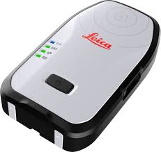
Leica Zeno FLX100 Smart Antenna
Long Description
Leica Zeno FLX100 Smart Antenna is a compact GNSS smart antenna designed for high-accuracy GIS data collection and mapping applications. Developed by Leica Geosystems, the FLX100 provides centimeter-level positioning accuracy in a lightweight and portable device that connects directly to smartphones or tablets for efficient field data capture.
The antenna supports multi-constellation GNSS tracking, including GPS, GLONASS, Galileo, BeiDou, QZSS, and SBAS satellites. With 184 tracking channels, it delivers reliable positioning even in challenging environments such as urban areas or dense vegetation. In RTK mode, the system can achieve horizontal accuracy of about 2 cm + 1 ppm and vertical accuracy of 3 cm + 1 ppm, making it suitable for professional GIS surveying and mapping tasks.
The Zeno FLX100 connects wirelessly via Bluetooth to Android or Windows devices running the Zeno Mobile app or other compatible data-collection software. This flexible configuration allows users to create a customized handheld GIS system using their own mobile device or mount the antenna on a survey pole for higher-precision measurements.
The unit features an internal rechargeable battery providing more than 20 hours of operating time, making it ideal for long fieldwork sessions. It also offers IP67 protection against water, dust, and harsh environmental conditions, ensuring reliable performance in demanding outdoor environments such as construction sites, utility mapping projects, and environmental surveys.
Because of its portability, accuracy, and easy integration with mobile devices, the Leica Zeno FLX100 is widely used by surveyors, GIS professionals, utility inspectors, and infrastructure engineers for tasks such as asset mapping, field data collection, land management, and infrastructure inspection

Reviews
There are no reviews yet.